This morning, as I do once per week, I mounted my bicycle and headed out to the Michiru Conservation Area to ascend Michiru Peak. Though I love the beauty and quiet rhythm of walking in nature, I decided to pay more attention to The Journey this time. And so, as I biked the 18 kilometers from my house to the mountain, I thought about the places I was passing.
Departing my driveway, I turned right. It’s a short uphill before the left turn onto Mandala Road, which connects the hospital where I work and Blantyre’s downtown. At first gradually downhill, I began to pick up speed as I passed the Vice President of Malawi’s house, followed by La Caverna (see the earlier blog entry “Lagniappe”). The Road steepened downhill and I zoomed past Blantyre Market. It is a sprawling indoor-outdoor locals market selling fruits and vegetables, colorful patterned fabrics, electronics and used clothes. Ever wonder where the things Goodwill and Salvation Army cannot sell end up? The Mudi River, a trash strewn, smelly, open sewer, bisects the market and marks the beginning of a long steep climb up to Blantyre’s compact downtown.
Entering downtown, I passed its few remaining colonial buildings including Victoria Hall (the former town hall, named for You Know Who) and the Surveys Office with its large “Map Sales” sign. The stoplight at the intersection was turned off because it was early on a Sunday morning. I cruised across the intersection passing the Blantyre Sports Club. Another former colonial bastion it has tennis courts and a freezing cold intermittently murky swimming pool. The best part about the Sports Club is that when golfing its nine-hole course, caddies must go down to the fairways before balls are driven off the tee. The caddies need to shoo away the monkeys who love to steal golf balls.
Though I kept my eyes on the track, I caught glimpses of the beautiful views on both sides.
I turned right and ascended Victoria Avenue (Her again…..) passing a grocery store on the left. In 2011, the first time I came to Blantyre, this was the first grocery store I entered. I wanted breakfast cereal. When I arrived at the appropriate aisle there was one choice, Corn Flakes, the least tasty breakfast cereal on Earth (or is that Weetabix?). Six grocery shelves, top to bottom, half an aisle, and the only brand in stock was Corn Flakes. It was like seeing a living Andy Warhol painting.
But I digress.
Victoria Avenue dead ends, and I took a quick left pedaling fast past a minibus stand. Minibuses are the most common mode of public transportation here in Malawi. They are cheap and always packed. Compared to other African countries where I have worked, Malawian minibuses are in poor repair. Their drivers are frightening, the least courteous people on the road. They do not signal or look prior to entering traffic. Pedestrians and other drivers know this, creating a negative feedback loop. Everyone dislikes them (well, perhaps not other minibus drivers) and I doubt they care. I hurried to get past.
The only redeeming feature of this minibus stand is that this is the location of the first sign pointing me to Michiru! Only 10 kilometers to go. Turning left I passed the palatial gates in front of the residence of the ambassador of Mozambique. Then began the long, steep, speedy downhill portion of this morning’s ride. At first it was residential but soon I entered the commercial area of Mbwerera, a township (poorer area) on the edge of Blantyre. The concrete block shops, 15 feet back from the roadside, sell mobile phones, meat, and funeral services. The main commercial action is closer to the street where wooden stalls sell produce at extremely low prices. Bargaining unnecessary.
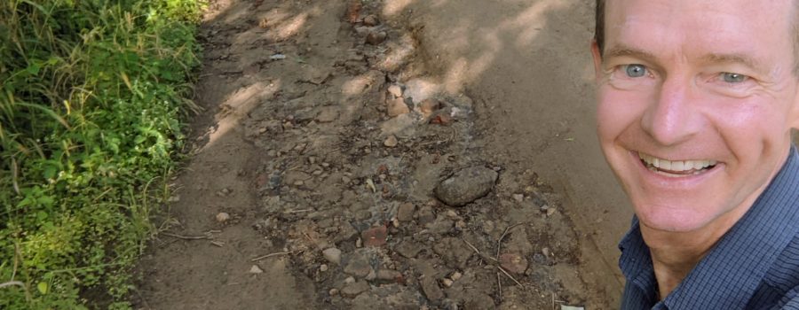
Zipping downhill through Mbwerera I crossed a small river and the pavement abruptly ended. The next 5 kilometers of road was uneven, full of holes, and washouts on both sides. Though I kept my eyes on the track, I caught glimpses of the beautiful views on both sides. On my left, maize fields stretched all the way to Michiru Mountain. To the right, the outskirts of Blantyre were mixed with green vegetation between me and Ndirande Mountain, 5 kilometers away.
Fifteen minutes later I entered the Michiru Conservation Area and saw my second and final distance indicator. It is another 3.4 kilometers to the ranger station, the beginning of the hiking trails. The sides of the track were grasses taller than me, intermixed with brilliant orange flowers. The tall trees overhead kept it cool. As the path deteriorated, I kept an eye out for animal poop indicating baboons were near. When I encountered the troop, I sang to them as I pedaled slowly through. For several years, my chosen song for this purpose has been “God Bless America”, the only tune that I can sing in good tune. As on previous encounters, the baboons yielded to my rendition of Irving Berlin.
From here, the dirt path grew more challenging. I crossed three rickety wooden bridges before arriving at the Ranger Station. I did it! Time to begin hiking.


